 DOCUMENTATION
Map, Traffic and Checklists
Three functions of the MFD flight pages: the EFA checklist reader, the moving MAP, and the EW system with its EW and EW HISTORY pages.
EFA - Electronic Flight Aid
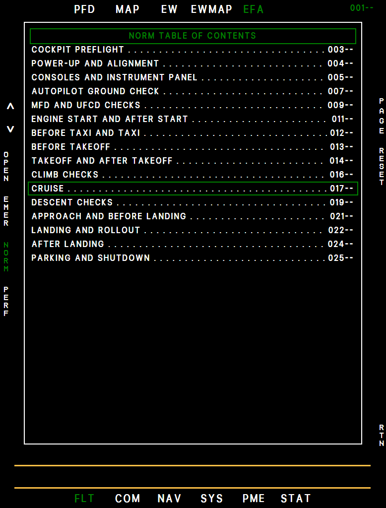
A built-in checklist reader. Page 000 is the PERF front page, 001 the table of contents of the normal checklists, and each checklist follows with a check box per step, so you can tick off what you have done. After them come the emergency checklists, with their own table of contents: engine cutoff, airstart and a stuck pogo, the three the simulation brings about by itself.
Example MFD efatoc
Example MFD efa
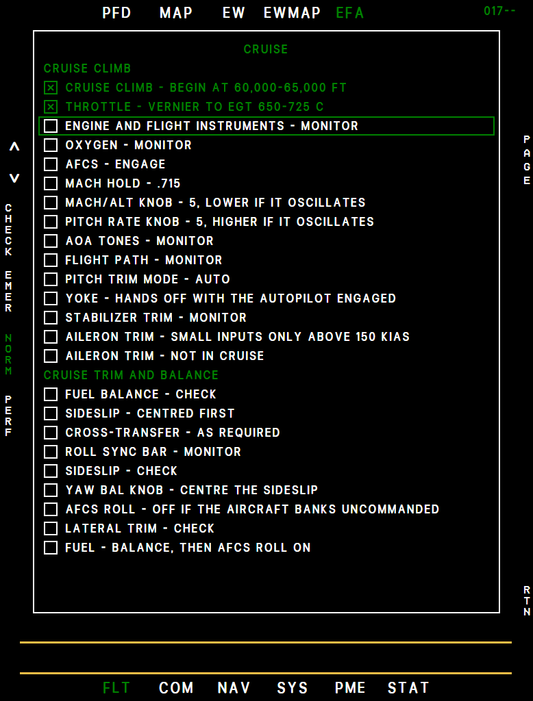
- Left rocker moves the selection box - over a checklist on the contents page, over a step inside a checklist. Right rocker turns the page.
- L1 OPEN opens the selected checklist; inside it L1 reads CHECK (or UNDO) and ticks the step, moving the box on.
- L2 EMER opens the emergency contents, L3 NORM returns to the normal contents (from PERF or EMER, to the normal page you had open), L4 PERF goes to the front page. R1 RESET on the contents page asks RESET ALL? in yellow beside R1 NO and R2 YES; the contents stay on screen. YES clears all ticks, any other key or rocker cancels.
- In the emergency section R5 TOC shows the emergency contents and R6 NORM the normal contents; R7 RTN returns to the page you had before. STAT/ICAW R3 SEL opens an alert's checklist when the EFA has one.
MAP
A moving map of the area around the aircraft, with land, sea, roads, cities, state borders and airports, and the U-2 symbology drawn on top of it. It is reached with B1 FLT, T2 MAP.
| Key | Legend | Function |
|---|---|---|
| Left rocker | - | Map scale: 10, 25, 100, 200 or 400 NM - the distance from the top to the bottom of the map - shown top right, in green. 100 when the flight loads. Hold the rocker to step quickly. |
| L1 | NORTH | North-up (green) or track-up (white). Track-up puts the aircraft a quarter of the way up the display. |
| L2 | DS | Direct steer: pick a DP number with the right rocker - any loaded DP of the ACTIVE file, or 00, the position the INS was aligned at - and press R1 ENT. An empty number is not sent. A dashed cyan line shows the proposed track; once sent it is solid. |
| L3 | OFLY | Overfly the next DP instead of turning early (F/T steering only). Confirm with YES. Yellow when on. |
| L4 | AMP | Amplified data: pick a file with R2 and a DP with the right rocker, R1 ENT, and read its position, bearing/range, time to go and fuel at the point. The files include TP, the targeting points; it is skipped without an imaging sensor. AC shows the aircraft's own data. |
| L5 | RCTR | Recenter the map on a chosen DP or TP (R2 picks the file). R1 ENT to apply. |
| L6 | SMBL | Symbol options: airports (ICAO), 15/30 NM range rings (RNGS), bullseyes, emergency fields, the ground track line (GTL), fix points (FPTS), how many DP labels to show (5 / 10 / 99), and a dimmer (BRT). |
| R4 | SCRL | Scroll the map with the arrow keys (R1 up, R2 down, R4 right, R5 left, a quarter of the scale per press). R3 EXIT leaves the map where it is - RCTR, then AC, brings it back to the aircraft. Not available while overfly is on. |
| R5 | ROZ | Restricted operating zones: a table of up to 24 circular zones (radius, position, display on/off, color) you can enter with the rocker or the UFCD pad. Zones show as colored rings on the map. |
All three MFDs share the map settings: the scale, NORTH / track up, the SMBL options and the map BRT. Change one on any display and the other two follow; the HSD map under the HSI uses the same scale. DS, AMP, RCTR, SCRL and ROZ, and a recentered or scrolled map, stay on the display where you used them.
What you see on the map:
- Green cross: your aircraft. Small magenta boxes: airports - every airfield, soft, water and private ones included, but no heliports or closed fields. The search covers the whole map and finds more at the wider scales, up to 900 at 400 NM; ICAO adds their identifiers.
- Magenta: the ACTIVE route with direction arrows. Legs are drawn on the great circle NAV flies, and each turn as a curve on the radius flown, from a small circle at the turn point, so the aircraft follows what you see. Two turns close together join up: the next turn starts where the last one ends.
DP numbers are on the left and names on the right of the "+". The next DP is green. While a direct-steer line is up, its DP shows no turn and the legs meet at the DP.
- Cyan dashed: a storage file under review (AMP), or the track of a direct steer you are still choosing. Cyan solid: a direct steer once it is sent, on every MFD, from whichever panel sent it (MAP, NAV/DPS, NAV/DATA, UFCD or BCDU). The line follows the aircraft until the nose or the ground track is within 2° of the DP, then stays in place as the course flown. It flashes 21 seconds before the turn and goes out as the turn begins.
- Yellow dashed: the overfly line. Green triangles: bullseyes. Red double circles: emergency fields. Black X: recorded fixes.
- Ground track line: where you will be in 5 minutes at the present bank.
- Thin pink line from the aircraft: the simulator map's own trend vector, a prediction at the present turn rate. It is not the route.
- Cyan crosshair in a box: where the camera looks and what its picture covers, while it is open (Mark IV Camera Panel).
- Yellow hollow triangles: targeting points, with their number below on the left and, with ICAO on, their name on the right. The TP picked on AMP or RCTR is green; without an imaging sensor they are gray. A magenta line shows a direct steer to a TP.
- Cyan fan: the radar's coverage while it radiates, with its cursor (placed by the hand control), and in SPOT a cyan square around the patch.
- A pending datalink upload appears as file UPLD under AMP, with ACPT / REJ.
EW System
Our rendition of the U-2S electronic warfare (EW) system uses the simulator's other air traffic - AI and multiplayer aircraft - as stand-ins for threat radars. Only aircraft moving faster than 20 kt count, so parked and taxiing traffic is ignored. You control it with the EW CONT switch at the top right of the main panel, next to the SFD.
The REC and RPT lamps beside it and a tone in your headset warn you of a close threat.
| EW CONT | Function |
|---|---|
| OFF | The EW system is off. The EW page shows EWS OFF / EW CONT OFF. While the AVP runs, 5 seconds in OFF (or without power) bring the advisory EW NO RESPONSE; it goes out once EW CONT is in REC or RPT. |
| REC | Receive: threat detection. Contacts on the EW pages, the REC lamp and the threat tone. |
| RPT | Repeat: detection plus self-protection jamming. As REC, and the RPT lamp flashes while a threat is being jammed. |
The EW system needs essential AC and essential DC power - ground power or a running engine. Without it the EW page reads EWS OFF / NO POWER. EW CONT is OFF after a Cold and Dark start; a runway start and the EFB Ready for takeoff preset put it in RPT for you.
Startup Self-Test
Each time EW CONT leaves OFF, the EW system runs a startup self-test before it reports anything: 30 seconds with the EFB option Avionics startup time on Fast (the default), 5 minutes on Realistic. While it runs, the EW page shows EWS STARTUP BIT and the time remaining (m:ss), and STAT/FAULT EW shows STARTUP BIT IN PROGRESS.
- Shortcut: with the EW system up, switch EW CONT to OFF for 1 to 3 seconds and back on - it comes straight back without the self-test.
- Less than a second in OFF changes nothing; a running self-test simply carries on.
- Anything else - more than 3 seconds off or without power, or 1 to 3 seconds while the self-test was still running - starts the full self-test again.
- A flight that loads with EW CONT already on skips the self-test.
Threats, Lamps and Tone
| Color | Contact | Symbol on the EW page |
|---|---|---|
| Red - threat | Within 5 NM and 1,000 ft of your altitude | Red wingform above the track number |
| Yellow - caution | Within 15 NM and 2,000 ft | Yellow wingform above the track number |
| Cyan | Any other contact, out to 400 NM | Cyan wingform above the track number |
- REC is lit while at least one red threat is tracked.
- RPT flashes (0.2 s on, 0.2 s off) while RPT is jamming a red threat. REC stays lit with it.
- The threat tone sounds once for each new red threat, and only with MSN RCD ON (PME power panel, right console; ON after a runway or in-flight start). The same aircraft sounds again only after it has been out of the red zone for 60 seconds. The volume is the THREAT knob times MASTER VOL, in four steps; either knob at its stop silences it.
- MASTER LIGHT TEST lights both lamps.
- Only red threats light the lamps and sound the tone, and threats put no messages on the MFD alert line. The EW system's own state does: EW NO RESPONSE (see EW CONT above) and EW IBIT TIMEOUT for a STAT/FAULT BIT that could not finish. The BCDU EW key stays inoperative.
EW Page
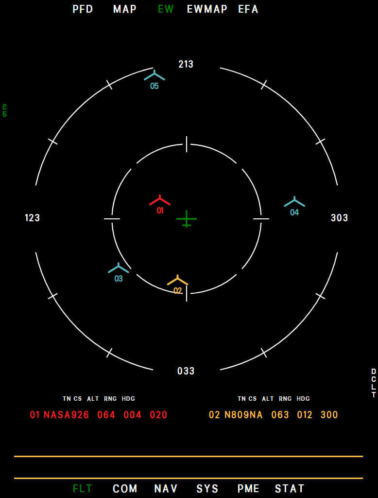
B1 FLT, T3 EW: a heading-up compass rose with you in the center and the outer ring at the selected range. While the EW system is off or in its self-test the page shows only its status box, black like the CAM and RDR status boxes, with the range and DCLT legends beside it: EWS OFF with EW CONT OFF or NO POWER below it, or EWS STARTUP BIT with the time remaining.
The box goes away when the system is up. It comes back as EWS IBIT IN PROGRESS while a STAT/FAULT BIT runs, with no contacts meanwhile.
Example MFD ew
- Range (NM)
- Heading (up)
- Own aircraft
- Red threat
- Yellow caution
- Cyan contact
- Threat list
- DCLT (R6)
- The nearest 25 contacts inside the range are drawn with the airborne-threat symbol: a small wingform above the contact's two-digit track number, in the colors of the table above.
- The box below the rose lists up to four yellow and red contacts, red first, then by range: track number, callsign, altitude in thousands of feet, range and heading (legend TN CS ALT RNG HDG).
- INC/DEC rocker: range 25, 50, 100, 200 or 400 NM (100 when the flight loads), shown down the left side. It wraps from 400 back to 25.
- R6 DCLT steps through all symbols / no legend / yellow and red only. The legend is green while declutter is on.
EW HISTORY Page (EWMAP)
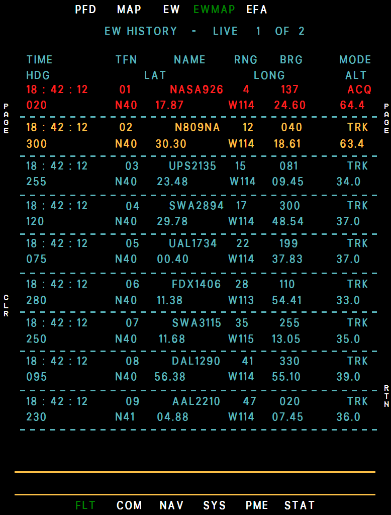
T4 EWMAP opens the page titled EW HISTORY. In our rendition it is a live list, not a recording: every contact the EW system tracks right now, nearest first, nine to a page (LIVE and the page count at the top).
Each row is in the color of its threat level and shows TIME (Zulu), TFN (the track number used on the EW page), NAME, RNG, BRG, MODE (ACQ inside 5 NM, TRK beyond), HDG, LAT, LONG and ALT (thousands of feet).
Example MFD ewmap
- LIVE list
- Page count
- Time (Zulu)
- Track number
- Name
- ACQ (inside 5 NM)
- Altitude (1000 ft)
- CLR (L4)
- RTN (R6)
- INC/DEC rocker: turn the pages.
- L4 CLR, then L4 YES (or L5 NO) empties the list; the contacts come back with the next update.
- R6 RTN returns to the page you came from.
Both EW pages show contacts only while the EW system is up.